> ## Documentation Index
> Fetch the complete documentation index at: https://docs.mapxagent.com/llms.txt
> Use this file to discover all available pages before exploring further.
# Exporting maps, data, charts, and reports
> Take work out of MapX: map images, layer data as GeoJSON or Shapefile, chart PNG and CSV, HTML / Word / PowerPoint reports, and project manifests.
MapX exports fall into four groups, and each one starts from a different place in the workspace:
| What you want | Where it starts | Format |
| - | - | - |
| A picture of the map | Share panel → **Social media share** | PNG |
| The data behind a layer | Layers panel → row download, or batch download | GeoJSON, FlatGeobuf, GeoPackage, Shapefile (zip) |
| A source file you uploaded | Data panel → row **Download** | Original file |
| A chart | Charts panel → chart export | PNG, SVG, CSV |
| A document | Reports panel → row menu | HTML, Word, PowerPoint, PDF |
| The project's layout and styling | Settings panel → **Export manifest** | `manifest.zip` |
## Plan availability
| Export | Free | Basic | Pro | Business |
| - | - | - | - | - |
| Share a map image | ✓ (watermark) | ✓ | ✓ | ✓ |
| Embed the map | ✓ | ✓ | ✓ | ✓ |
| Share a report link | ✓ | ✓ | ✓ | ✓ |
| Download layers and files | ✗ | ✓ | ✓ | ✓ |
| Export a project manifest | ✗ | ✓ | ✓ | ✓ |
| Share the project with another user | ✗ | ✗ | ✓ | ✓ |
Downloading data requires **Basic or higher**. On Free you can analyse and visualise data in the project, but not download it. The row shows **Upgrade to download** in place of the download action.
## A map image
The high-resolution PNG comes from the **Share** panel, where you also choose the aspect ratio, resolution, watermark, 3D perspective, pinned chart, and legend placement. It downloads straight to your browser and is never uploaded anywhere.
See [Sharing](/en/sharing/sharing-maps#generate-a-share-image) for the full walkthrough.
## Layer data
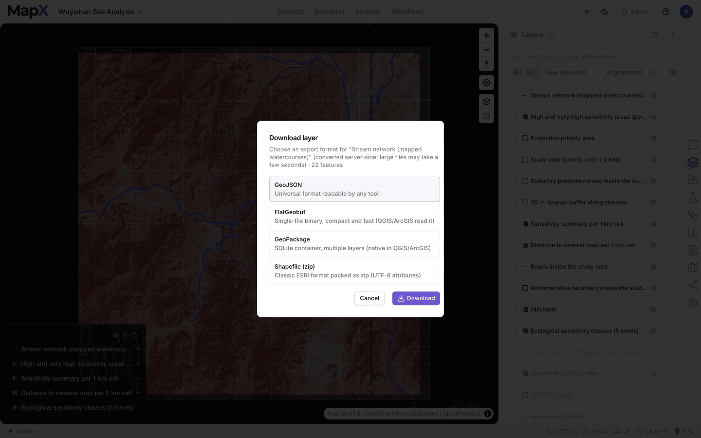
Every vector layer can be exported on its own, in the format your downstream tool wants. Open the layer row's **⋯** menu and choose **Download**:
| Format | When to pick it |
| - | - |
| **GeoJSON** | Universal — readable by any tool, and the default |
| **FlatGeobuf** | Single-file binary, compact and fast; QGIS and ArcGIS read it |
| **GeoPackage** | SQLite container that holds multiple layers natively in QGIS and ArcGIS |
| **Shapefile (zip)** | Classic ESRI format, packed as a zip with UTF-8 attributes |
Only the formats your deployment's GDAL build supports appear in the dialog; **GeoJSON** is always available. Raster layers export as images, not as vector formats.
Exported geometry keeps the coordinates the layer was stored with. If a layer has no declared coordinate system, the dialog says so — *"Not declared (assumed WGS 84 from lon/lat range)"* — and treats longitude/latitude values as WGS 84.
 ### Several layers at once
Turn on batch select in the Layers panel, tick the layers you want, and choose **Download**. MapX packages the selection into a single zip instead of asking you to download layer by layer.
Downloads contain the **current** state of the layer, including fields added or changed by analysis and editing. If a layer is mid-edit in a shared project, commit the edit first so everyone exports the same revision.
## Source files
Your uploaded files are untouched by analysis, so the Data panel keeps the original. Each row has a **Download** action that returns the file exactly as you uploaded it — useful when you need the original CSV, spreadsheet, or document rather than the derived layer.
## Charts
Charts export from the Charts panel in three formats:
| Format | Use it for |
| - | - |
| **PNG** | Slides, documents, chat — rendered with the same theme as the on-screen chart |
| **SVG** | Vector editing and print; scales without blurring |
| **CSV** | The underlying numbers, for spreadsheets or another charting tool |
Exporting a chart uses the chart's own background and colours, including transparency. See [Charts](/en/concepts/charts) for building and pinning charts.
## Reports
Reports are files in the project, and the Reports panel is the export surface. Each row offers:
* **Preview report** — opens the report in a new tab.
* **Export PDF** — renders the report to PDF on the server, then downloads it.
* **Download report** — downloads the file in the format it was generated in: **HTML**, **Word**, or **PowerPoint**.
To send a report to someone instead of downloading it, use **Copy share link** from the same menu — see [Sharing](/en/sharing/sharing-maps#share-a-report-link). Only HTML reports can be shared by link.
For the report builder itself and what each format includes, see [Reports](/en/concepts/reports).
## Project manifest
A manifest packages the project's **map state and layer configuration** — basemap, layer styles, labels, legends, and visibility — into `-manifest.zip`. It describes how the project looks and is arranged; it is not a data backup.
In the workspace rail, open **Settings** (the gear icon).
The section is enabled on Basic and above; on Free it points at the upgrade page instead.
The browser downloads `-manifest.zip`, which contains the manifest describing the layers and their styling.
## Related
* [Sharing](/en/sharing/sharing-maps) — embed links, live view URLs, report links, and project access
* [Files](/en/concepts/files) — how uploads are stored, shared, and replaced
* [Charts](/en/concepts/charts) — build the chart before you export it
* [Reports](/en/concepts/reports) — build the document before you export it
This documentation is built and hosted on [Mintlify](https://mintlify.com), a developer documentation platform.
### Several layers at once
Turn on batch select in the Layers panel, tick the layers you want, and choose **Download**. MapX packages the selection into a single zip instead of asking you to download layer by layer.
Downloads contain the **current** state of the layer, including fields added or changed by analysis and editing. If a layer is mid-edit in a shared project, commit the edit first so everyone exports the same revision.
## Source files
Your uploaded files are untouched by analysis, so the Data panel keeps the original. Each row has a **Download** action that returns the file exactly as you uploaded it — useful when you need the original CSV, spreadsheet, or document rather than the derived layer.
## Charts
Charts export from the Charts panel in three formats:
| Format | Use it for |
| - | - |
| **PNG** | Slides, documents, chat — rendered with the same theme as the on-screen chart |
| **SVG** | Vector editing and print; scales without blurring |
| **CSV** | The underlying numbers, for spreadsheets or another charting tool |
Exporting a chart uses the chart's own background and colours, including transparency. See [Charts](/en/concepts/charts) for building and pinning charts.
## Reports
Reports are files in the project, and the Reports panel is the export surface. Each row offers:
* **Preview report** — opens the report in a new tab.
* **Export PDF** — renders the report to PDF on the server, then downloads it.
* **Download report** — downloads the file in the format it was generated in: **HTML**, **Word**, or **PowerPoint**.
To send a report to someone instead of downloading it, use **Copy share link** from the same menu — see [Sharing](/en/sharing/sharing-maps#share-a-report-link). Only HTML reports can be shared by link.
For the report builder itself and what each format includes, see [Reports](/en/concepts/reports).
## Project manifest
A manifest packages the project's **map state and layer configuration** — basemap, layer styles, labels, legends, and visibility — into `-manifest.zip`. It describes how the project looks and is arranged; it is not a data backup.
In the workspace rail, open **Settings** (the gear icon).
The section is enabled on Basic and above; on Free it points at the upgrade page instead.
The browser downloads `-manifest.zip`, which contains the manifest describing the layers and their styling.
## Related
* [Sharing](/en/sharing/sharing-maps) — embed links, live view URLs, report links, and project access
* [Files](/en/concepts/files) — how uploads are stored, shared, and replaced
* [Charts](/en/concepts/charts) — build the chart before you export it
* [Reports](/en/concepts/reports) — build the document before you export it
This documentation is built and hosted on [Mintlify](https://mintlify.com), a developer documentation platform.